Satellite data shows NO2 concentration in Metro Manila down to pre-fire levels for two consecutive days
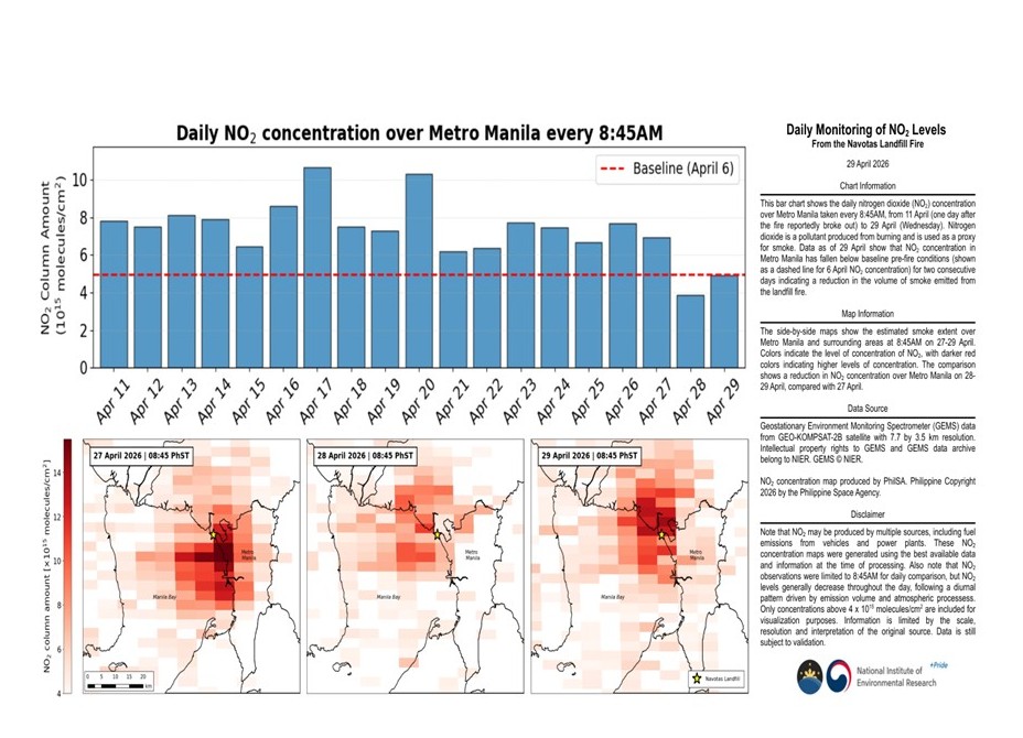
(29 April 2026, Quezon City) The Philippine Space Agency (PhilSA) has been conducting daily monitoring of satellite data since the Navotas landfill fire reportedly broke out on April 10, 2026. Coinciding with reports on Tuesday (28 April) that significant progress has been made in suppressing the fire, satellite data show that the nitrogen dioxide (NO2) concentration in Metro Manila has fallen below the levels of 6 April (pre-fire) for two consecutive days. Nitrogen dioxide is a pollutant produced from burning and is a component of smoke, and lower NO2 concentrations indicate a reduction in the volume of smoke emitted from the landfill fire. Observations are consistent with measurements on the ground by EMB NCR and Central Luzon that particulate matter or PM over Metro Manila has improved on Tuesday (28 April) and Wednesday (29 April). PhilSA will continue monitoring NO2 to assist in quantifying the impact of ground interventions. Please follow local and national health agencies for the latest advisories.
The side-by-side maps compare the estimated smoke extent over Metro Manila at 8:45 AM on 27-29 April. Colors indicate the level of concentration of NO2, with darker red colors indicating higher levels of concentration. Data show a reduction in NO2 concentration levels over Metro Manila on 28-29 April, compared to 27 April and previous days. This is also supported by the time-lapse video showing daily snapshots at 8:45 AM from 11 April (one day after the fire reportedly broke out) to 29 April (Wednesday).
NO₂ may be produced by multiple sources, including fuel emissions from vehicles and power plants. Please note that NO2 observations were limited to 8:45 AM for daily comparison, but NO2 levels generally decrease throughout the day, following a diurnal pattern driven by emission volume and atmospheric processes.
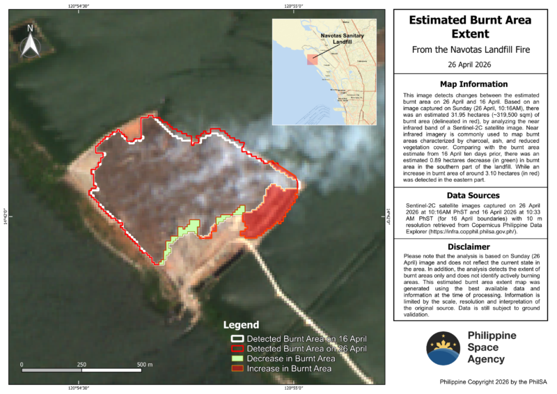
PhilSA has also been monitoring the estimated burnt area extent at the Navotas landfill by analyzing the near infrared band of Sentinel-2C satellite images. Near infrared imagery is commonly used to map burnt areas characterized by charcoal, ash, and reduced vegetation cover. Based on a satellite image captured on Sunday (26 April, 10:16 AM), there was an estimated 31.95 hectares (~319,500 sqm) of burnt area (delineated in red). Comparing with the burnt area estimate from 16 April, there was an estimated 0.89 hectares decrease (in green) in burnt area in the southern part of the landfill, while an increase of around 3.10 hectares (in red) was detected in the eastern part. Please note that the analysis is based on the Sunday (26 April) image and does not reflect the current state in the area. In addition, the analysis detects the extent of burnt areas only and does not identify actively burning areas (ang mga lugar na sunog na, hindi ang mga lugar na nasusunog). A version of this map has been provided to the NDRRMC.
PhilSA’s support through the analysis of satellite data provides wide-area coverage that assists the NDRRMC in monitoring the situation and prioritizing areas for response. By making space data accessible to stakeholders, PhilSA enables informed decision-making and strengthens disaster response.
Read this on our website: https://philsa.gov.ph/news/satellite-data-shows-no2-concentration-in-metro-manila-down-to-pre-fire-levels-for-two-consecutive-days/