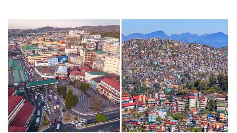
Land use plan on final stages

The updated Comprehensive Land Use Plan (CLUP) for 2024 to 2032 which will chart the city’s physical and economic development for the next eight years is now in the final stages of completion and will soon be submitted to the city council for deliberation and action.
The City Planning, Development and Sustainability Office (CPDSO) under Coordinator Arch. Donna Tabangin said the updating took years to complete due to the need for extensive public consultations and research with the barangays and stakeholders to gather and consolidate data for the different zones.
In a report to the Management Committee headed by Mayor Benjamin Magalong last Nov. 4, Tabangin said they were able to conduct more than 500 barangay consultations to complete the plan.
She said they also decided to do planning at the barangay level and come up with a Barangay Land Use Plan (BLUP) for each of the barangay aimed at harmonizing zoning and land use plans at the grassroots level. These BLUPs are now being consolidated to form part of the CLUP.
Tabangin said planning, prewriting, researching, data collection, organizing, outlining and drafting phase of the BLUP in the city’s 128 barangay was completed last October 30, 2025 while the revising, editing, proofreading, finalizing, printing will be done on December 15, 2025. They expect to submit the consolidated CLUP and Proposed Zoning Code to the city council for deliberation and action by December 23.
Tabangin said the CLUP will include data on the city’s protected areas, drainage and river basins. The need to merge infrastructure requirements with land identities and zones was also addressed.
The CLUP’s contents include the city’s demographic profile (household distribution and age-sex distribution, age group and sex distribution); biophysical profile (administrative boundaries and land area, elevation, slope, soil classification, drainage and river basins, protected areas, ancestral domain/ancestral lands, heritage and cultural assets, land ownership, proclamation, growth nodes development framework, etc.; existing land use and zoning; barangay infrastructure (electric connection, access, water supply, liquid and solid waste, public facilities, open spaces, heritage or cultural assets);Development constraints (City Disaster Risk Assessment, Social Vulnerability Index, Baguio City’s Carrying Capacity, Urban Heat Island, GHG Emission, Accessibility Risk); Barangay Livability Index and Land Use Standards; Comparative Advantages and Competitive Edge; Barangay Land Use and Zoning (role of barangay to city, barangay zoning, building heights, barangay urban design, nature-based solutions; and Smart Sustainable Cities with focus on the Sustainable Development Goals (SDGs).
The BLUPs, meanwhile, contains the barangay’s demographic profile, biophysical profile, existing land use and zoning, barangay infrastructure, development constraints, barangay livability index and land use standards, comparative advantages and competitive edge, proposed barangay land use and zoning.
It also includes the role of barangay to overall city development and recommendations for development on Net Zero, nature-based solutions, circular economy transition, Smart City/Digital Twin, and Sustainable Development Goals (SDGs). – Gaby B. Keith and Aileen P. Refuerzo