Study on urban heat islands presented in Climate Change summit, impacts shown

Data on urban heat island (UHI) presented during the first climate change summit; Feb. 9 and 22, shows the effect of rapid urbanization to the greenhouse effect and global warming.
The Urban Heat Islands (UHI) is a biophysical data analysis done two years ago, to determine the effect of urbanization on land surface and air temperature in Baguio, Quezon City, Cebu, Iloilo, Zamboanga and Davao.
Funded by the Department of Science and Technology (DOST), the project was requested by Mayor Benjamin Magalong for presentation by Engr. Nathaniel Lubrica of the University of the Cordilleras (UC).
The mayor as keynote speaker in the summit presented stark details and eye-openers on the city’s carrying capacity, breached basic services; yet expressed hope for the local government programs and residents’ steps, in urban re-greening and reduction of carbon footprint.
Engr. Lubrica presented the circumstances of having an urban area warmer than the rural areas surrounding it, through gas emissions, human activities and built-up areas enhancing a rapid change in surface cover. Findings show that the different land types or impervious surface areas could affect the findings.
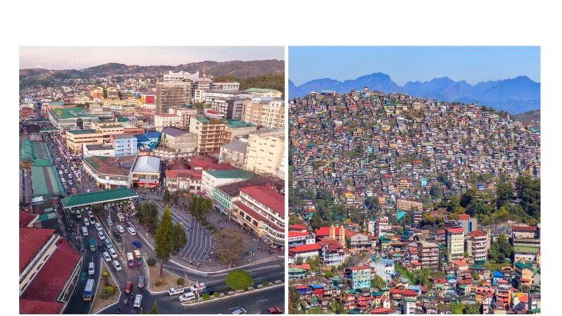
Hotspots were detected at the central business district (CBD), which from 1998 to 2011 gradually expanded up to 40 hectares; and from 2014 to 2019 increased extensively to 305 ha.
On the average, 98.5% of the hotspots detected from 1995 to 2019 are within the built-up area. In a 6000 hectare (ha) area, from 2013 to 2019; vegetation lessened from 4883.85 to 3544.02, while build-up areas went up from 1094.4 to 2394.99.
Additional maps presented by Lubrica show the hottest years within summer, in 2019, 2018, 2006, and 2002, from 28 C to 30 C; and the coldest years within summer, in 1999, 1997, 1996, 1995, 1988, 25 C to 26 C.
As the study revealed, there was no correlation for temperatures within each season, and not even between the dry and wet seasons. But the increase in the built-up areas intensified Land Surface Temperature (LST) during the dry season.
The study impacts are:
• Better policies in land use planning could be done through understanding the implication of urbanization to land use.
• Results of the study were incorporated in the revisited Burnham Park Development and inputs to Baguio’s land use plan which included the Session Road Pedestrianization design.
• Outputs of the study include development for the academe and local government units, learning modules for researchers, software for LST and maps, and innovative technologies and inventions for lowering land surface temperatures.
• Urban gardening and other climate change initiatives and Baguio’s policies are strengthened through this study
• The study could also serve as a model for other land use analysis, Engr. Lubrica ended.
Most importantly, the study shows areas where trees should be planted and nurtured, as they intercept and absorb rain, thus reduce stormwater run-off; absorb and store carbon dioxide; create shade, thus reduce energy demand or waste heat from air conditioners; clean air by taking in air pollutants; block sunlight which keeps ground temperature down; and through the process of evapo-transpiration absorb water and release it through their leaves thus cool the surroundings.
Thus, urban areas or land undergoing rapid build-up need trees to help cool down said areas.
Spearheaded by the local government, the climate change summit had the theme “Sama-samang Tumutugon sa Hamon ng Nagbabagong Klima.”- JGFianza